
Roanoke River Greenway is the region’s signature project, the backbone of the greenway network following the river from west to east through the valley. Currently, the focus is on finishing the 25 miles from Green Hill Park in west Roanoke County, through the Cities of Salem and Roanoke, connecting to the Town of Vinton, and then back to western Roanoke County, the Blue Ridge Parkway, and Explore Park.
Interactive Trail Map

The Roanoke River Greenway System
Trail Details
Trail Distance:
1 mile
Amount of Use:
heavy
Trail Difficulty:
easy
Surface Type:
Paved
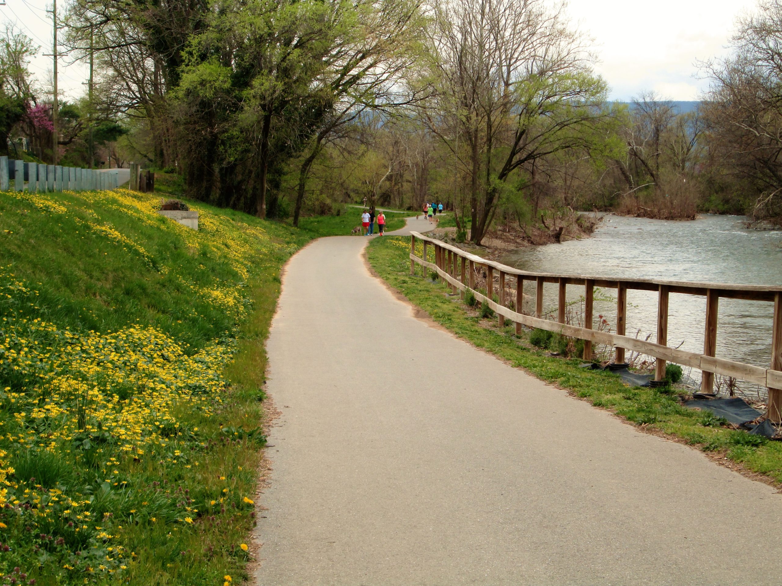
Roanoke River Greenway at Green Hill Park
The section of Roanoke River Greenway within Green Hill Park is a paved path 0.8 miles long. The greenway begins at the parking area near the park entrance off Diuguids Lane and parallels the river to the back parking lot. The path has numerous benches and resting points and provides access to several fishing spots. […]
Trail Details
Trail Distance:
0.86 mile
Amount of Use:
medium
Trail Difficulty:
easy
Surface Type:
Paved
Roanoke River Greenway in Salem
The sections of Roanoke River Greenway in Salem include a ¼-mile connection from Woodbridge Road to Mill Lane, a 3.5-mile section from West Riverside Park to Rotary Park, and a 0.6-mile section from Cook Drive to Barnhardt Creek. While these off-road sections are not continuous, it is relatively easy for bicycles to connect using on-street […]
Trail Details
Trail Distance:
4.4 mile
Amount of Use:
medium
Trail Difficulty:
easy
Surface Type:
Paved
Roanoke River Greenway near Peters Creek Extension
The section of Roanoke River Greenway near Peters Creek Extension is 1.7 miles long with parking on Blue Ridge Drive and near the end of Aerial Way. This portion is behind industrial areas, with good views of the river, and a large bridge crossing over to the railroad materials yard. This section has lots of […]
Trail Details
Trail Distance:
1.1 mile
Amount of Use:
light
Trail Difficulty:
easy
Surface Type:
Paved
Roanoke River Greenway from Bridge Street to Tinker Creek Greenway
The longest continuous section of Roanoke River Greenway is 8 miles from Bridge Street to Tinker Creek Greenway at the Water Pollution Control Plant. This section connects many neighborhoods and parks and is heavily used. While most of it is off-road, ¾ mile from Bennington to Underhill shares neighborhood streets. The large bridges crossing the […]
Trail Details
Trail Distance:
14.2 mile
Amount of Use:
heavy
Trail Difficulty:
easy
Surface Type:
Paved
Recommended Activities
Rules, Regulations
& Etiquette
Trail Rules
Some trails cross jurisdictions along route. Rules vary by jurisdiction.
System-Wide Rules:
- Yield to pedestrians.
- Keep to the right, pass on the left.
- Give an audible warning when passing.
- Maintain safe, courteous speeds.
- Keep pets on a leash.
- Clean up after pets.
- Keep the greenway trash free.
- No trespassing after hours.
- No motor vehicles.
- No alcohol, camping, hunting, or fires.
City of Roanoke Hours:
- Hours: 6 am – 11 pm.
City of Salem Hours:
- Hours: Dawn to dusk.
Roanoke County Hours:
- Hours: 6 am -9 pm.
Trail jurisdiction
This trail crosses the following jurisdictions:
City of Roanoke City of Salem Roanoke CountyGeneral Trail Etiquette
- Share the trail.
- Slow down when congested.
- Do not take up more than half the trail.
- Keep leashes short.
- Wear appropriate safety equipment.
- Step off the trail when stopping.
- Scoop the poop immediately.
- Carry trash to waste receptacles.
×