Alert Icon

Roanoke County seeks input on Roanoke River Greenway to Green Hill Park

Alert Icon

20K for the Greenway, June 10th

Come out and support the Greenways by participating in this family-friendly event. Sponsored by Cardinal Bicycles, Pathfinders for Greenways, PedalSafe ROA and the City of Roanoke’s Parks and Recreation Department, this ride is designed to give casual riders a non-competitive event experience and to support the organizations that make the Greenways possible. More details can […]

Trail Details

Trail Distance:
mile
Amount of Use:
Trail Difficulty:
Surface Type:

Bridge St Section of Roanoke River to open July 28th! Join us for the Ribbon Cutting!

The long awaited “Bridge the Gap” section of the Roanoke River Greenway in the City of Roanoke, connecting the current Bridge St Trailhead with the section along Aerial Way, will open officially at 10am on July 28th. The public is invited to join in the celebration, there will be coffee and snacks as well as […]

Trail Details

Trail Distance:
mile
Amount of Use:
Trail Difficulty:
Surface Type:

Brief closure of a section of Roanoke River Greenway this Wednesday

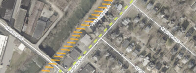
As AEP continues to work on upgrading their equipment, there will need to be another temporary closure and detour of the Roanoke River Greenway. This Wednesday, 1/26, the closure will be in the vicinity of the Walnut Avenue Bridge. Greenway users will be routed on to neighborhood roads from 6am to 6pm to avoid the […]

Trail Details

Trail Distance:
mile
Amount of Use:
Trail Difficulty:
Surface Type:
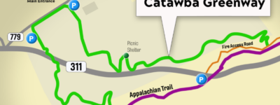
Location of new Catawba Greenway Trail

Catawba Greenway now open

Long in the making, the Catawba Greenway was formally unveiled on the last day of September. Connecting Virginia Tech’s Catawba Sustainability Center with the Appalachian Trail near McAfee Knob, the new trail creates a little over a 5 mile-loop for hikers who wish to access the AT without worrying about parking on the top of […]

Trail Details

Trail Distance:
mile
Amount of Use:
Trail Difficulty:
Surface Type:

Clean Valley Day Clean Up On Tinker and Glade Creek Greenways, April 9th

Come join us for a litter clean up on the Greenway April 9th from 9 until noon. We will be meeting at the Dale Ave SE Trailhead for Tinker Creek Greenway. Wear clothes you can get dirty and sturdy shoes, bring water, and we will provide the rest. Any questions please contact Frank Maguire.

Trail Details

Trail Distance:
mile
Amount of Use:
Trail Difficulty:
Surface Type:

Detour on Roanoke River Greenway *UPDATE*

UPDATE: Work completed! Starting August 28th, there will be a detour on the Roanoke River Greenway at the Bennington Rd Trailhead. Access to the trailhead itself will be limited and users wishing to continue on ( or are coming from) towards the Sewage Treatment Plant will be routed onto Bennington Rd near the Shell Gas […]

Trail Details

Trail Distance:
mile
Amount of Use:
Trail Difficulty:
Surface Type:

High water forces temporary closure of Roanoke River Greenway and Tinker Creek

Due to the rain and the forecast for more in the coming days, the section of the Roanoke River Greenway that parallels Wiley Drive between Wasena and the second low water bridge will be closed from today, Tuesday May 24th until further notice. Tinker Creek Greenway is also flooded near Dale Ave and near Kenwood, […]

Trail Details

Trail Distance:
mile
Amount of Use:
Trail Difficulty:
Surface Type:

Missing Link in Roanoke River Greenway to start construction this Spring

Roanoke City has awarded a contract to Allegheny Construction to construct the approximately one mile section of trail from the current Bridge St Trailhead to the section that currently ends at the Norfolk-Southern Materials Yard. This project has been the focus of the city, the Greenway Commission and the Pathfinders for Greenways for years, and […]

Trail Details

Trail Distance:
mile
Amount of Use:
Trail Difficulty:
Surface Type:

National Public Lands Day, September 17th

Join Roanoke County and fellow trail enthusiasts at Explore Park for a day of giving back to our public lands. The project will be to reroute a section of the Yellow Trail between Chestnut Ridge Road and the Blue Ridge Bike Park. We will be constructing about 700 feet of new bench cut trail and […]

Trail Details

Trail Distance:
mile
Amount of Use:
Trail Difficulty:
Surface Type:

Rains bring multiple closures of the Greenway on February 13th.

An Update from Roanoke City Parks and Recreation – We got a lot of rain yesterday in the valley and surrounding mountains. This morning the Roanoke River is 5,000cfs, highest we have been since May 2022. With that, we are underwater in the following areas and will clean up debris once the water recedes. We […]

Trail Details

Trail Distance:
mile
Amount of Use:
Trail Difficulty:
Surface Type:

Repaving completed on eastern end of Roanoke River Greenway.

The City of Roanoke’s Parks and Recreation Department has completed the repaving of the Roanoke River Greenway from the the Bridge at Bennington Road to the Shell Station. This project was necessitated by the growth of invasive trees along the greenways, which had buckled the pavement. The Pathfinders’ Midweek Crew helped city staff remove the […]

Trail Details

Trail Distance:
mile
Amount of Use:
Trail Difficulty:
Surface Type:

Roanoke County seeks input on Roanoke River Greenway to Green Hill Park by May 10th

Roanoke County held a community meeting to discuss the progress of the Roanoke River Greenway between the current end in Salem and Green Hill Park on April 11th. If you were unable to make it to the meeting, the county has a survey seeking input from the community, open until May 10th. Project details and […]

Trail Details

Trail Distance:
mile
Amount of Use:
Trail Difficulty:
Surface Type:

Roanoke County to hold meetings on potential for West Roanoke River Greenway

Roanoke County is conducting a Feasibility Study for the Roanoke River Greenway between Green Hill Park and Montgomery County. This proposed extension of the Greenway has long been a goal of the Greenway Commission and has appeared on every vision map since the first Greenway Plan was adopted. This section has gotten some new energy […]

Trail Details

Trail Distance:
mile
Amount of Use:
Trail Difficulty:
Surface Type:

Roanoke River Greenway in Salem to be temporarily closed

Beginning today, January 9th, and lasting until late February, The Roanoke River Greenway near the Moyer Sports Complex will be closed as the City of Salem continues construction to the facility. We’ll update the site when the trail is re-opened. Thank you for your patience.

Trail Details

Trail Distance:
mile
Amount of Use:
Trail Difficulty:
Surface Type:

Roanoke River Greenway Repaving!

If you have traveled on the Roanoke River Greenway near the Bennington Rd Trailhead, you have undoubtedly noticed the pavement has risen up in several sections, making for a jarring, possibly dangerous surface. These pavement heaves are caused by the adjacent invasive trees, whose roots have grown under the pavement in search of water. Beginning […]

Trail Details

Trail Distance:
mile
Amount of Use:
Trail Difficulty:
Surface Type:

Support the Greenways through Roanoke Gives

The Annual Roanoke Gives Fundraising Campaign is this Wednesday, April 19th. Pathfinders for greenways is participating, so if you would like to see the Greenways throughout the Roanoke Valley continue to grow and thrive, please consider giving this week. You can find more information here.

Trail Details

Trail Distance:
mile
Amount of Use:
Trail Difficulty:
Surface Type:

Take the survey to Support the East Roanoke River Greenway

Help complete the East Roanoke River Greenway! Roanoke County and VDOT are working on the potential future alignment of the Greenway from Roanoke City to the Blue Ridge Parkway. Funding for this project is dependent on demonstrated community support, so the more people we can get to take the survey and say “yes, I want […]

Trail Details

Trail Distance:
mile
Amount of Use:
Trail Difficulty:
Surface Type:

Temporary closure of Roanoke River Greenway Section – UPDATE

The work has been completed and the Greenway is now open. AEP will being doing utility work in the area where the Roanoke River Greenway goes under Jefferson St SW, near the Carilion Roanoke Memorial Hospital, necessitating a closure and detour. Greenway Users can follow Wiley Dr. under the Norfolk Southern bridge and return to […]

Trail Details

Trail Distance:
mile
Amount of Use:
Trail Difficulty:
Surface Type:

Wolf Creek Greenway closed at Route 24 Bridge

UPDATE: as of 1/26, the underpass was re-opened. Due to the need for emergency repairs related to an accident, The Wolf Creek Greenway underpass of Route 24 will be temporarily closed as of January 2nd, 2024. Repair work will begin shortly and should be completed by January 26th, 2024.

Trail Details

Trail Distance:
mile
Amount of Use:
Trail Difficulty:
Surface Type:
Trees

Roanoke Valley Greenways Trail Finder

horseshoe mtnbike bike hiking shoes paw-print roller-skate disability

How will you hit the trail?

Find new trails for your favorite motivation method

Or visit the full trail list here