
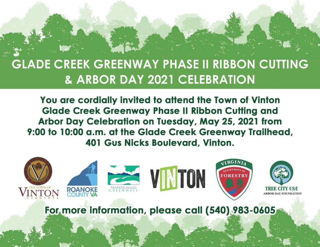
Roanoke City to close Roanoke River Greenway in Wasena beginning Monday, April 29th.
April 26th, 2024The Greenway Commission was notified this afternoon (Friday, April 26th) that the Greenway underneath the Wasena Bridge will be closed beginning on April 29th for the duration of the construction. The project is expected to take between two and three years. A detour has been marked by the city, but Greenway users should use extreme caution while traversing the re-route, as they will be sharing the street with automobile traffic.
IF you have any concerns about this, please direct your questions and comments to the Director of Public Works or the City Manager.
Roanoke County seeks input on Roanoke River Greenway to Green Hill Park by May 10th
April 4th, 2024Roanoke County held a community meeting to discuss the progress of the Roanoke River Greenway between the current end in Salem and Green Hill Park on April 11th. If you were unable to make it to the meeting, the county has a survey seeking input from the community, open until May 10th.
Project details and a link to the survey can be found at the county project website.
Wolf Creek Greenway closed at Route 24 Bridge
January 2nd, 2024UPDATE: as of 1/26, the underpass was re-opened.
Due to the need for emergency repairs related to an accident, The Wolf Creek Greenway underpass of Route 24 will be temporarily closed as of January 2nd, 2024. Repair work will begin shortly and should be completed by January 26th, 2024.
Pathfinders for Greenways 2023 Newsletter
November 26th, 2023
|


Celebrate Over 100 Miles of Trails on NPLD
September 10th, 2023Note, the trail work portion of this event has been cancelled due to heavy rain. But the celebration at Star Hill is still on at noon.
Pathfinders For Greenways is proud to take part in the National Public Lands Day event that the City of Roanoke Parks and Recreation is hosting on Saturday the 23rd. Trail work, shirts, food, drink, celebration! Please come join the many local groups and volunteers that are participating!
Details Below:

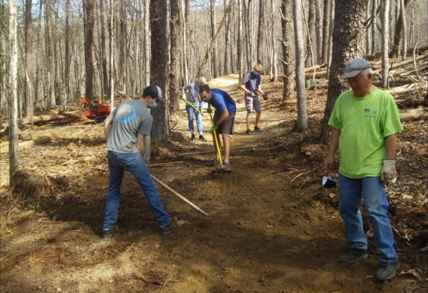
Earlier this year, the City of Roanoke surpassed 100 miles of trails and greenways managed by the Department of Parks and Recreation. In recognition of this accomplishment, Roanoke Parks and Recreation is hosting Volunteer Trail Work and a Celebration of 100+ Miles of Trails and Greenways, to be held on National Public Lands Day, September 23. Established in 1994, National Public Lands Day (NPLD) is traditionally the nation’s largest single-day volunteer effort. This year, volunteers will continue to grow our local trails by working on Corridor 12 of the Mill Mountain Trails Plan. Join fellow trail enthusiasts–hikers, mountain bikers, trail runners and equestrians to start a new trail on Mill Mountain!
The National Public Lands Day project will begin at 8:00 AM. Volunteers will meet staff at the Mill Mountain Star Trail parking area off Riverland Road. Come ready to work with clothing that can get dirty, closed toes shoes, and a hat/sunscreen. All tools, gloves, and instruction will be provided. Pre-registration is appreciated, but not required.
Following the trail work, an after party and Celebration of 100+ Miles of Trails and Greenways will be held at Starr Hill Pilot Brewery.
All who appreciate our trails and greenways are invited to attend the celebration, whether you are a NPLD volunteer or not. The event will open at 12:00 PM, with festivities including volunteer recognition, giveaways, and an opportunity to hear from those involved in the continued work. Drinks are available for purchase at the brewery for all who attend. NPLD volunteers will receive a free t-shirt as well as lunch and one drink ticket.
——->
ALSO; Please check out the really cool Story Map that Roanoke City had Pat Davitt put together to celebrate this milestone event:
https://storymaps.arcgis.com/stories/aafd22e67a604c4ab2da4156d0a20038
Detour on Roanoke River Greenway *UPDATE*
August 28th, 2023UPDATE: Work completed!
Starting August 28th, there will be a detour on the Roanoke River Greenway at the Bennington Rd Trailhead. Access to the trailhead itself will be limited and users wishing to continue on ( or are coming from) towards the Sewage Treatment Plant will be routed onto Bennington Rd near the Shell Gas Station near Riverland Rd.
The closure is being made necessary by the construction of a new river access point under the 13th St Bridge. Construction is expected to be wrapped up by the end of October. Please obey the closure in the mean time and look forward to making use of the boat access in late fall or next year!
Crystal Spring Trail Closed until December 1
August 25th, 2023Crystal Spring Trail is in Mill Mountain Trail system.
The trail is closed in order for Roanoke Gas to run a high pressure larger line from Ivy down to Carilion.
If all goes well, it will be done by December 1st.
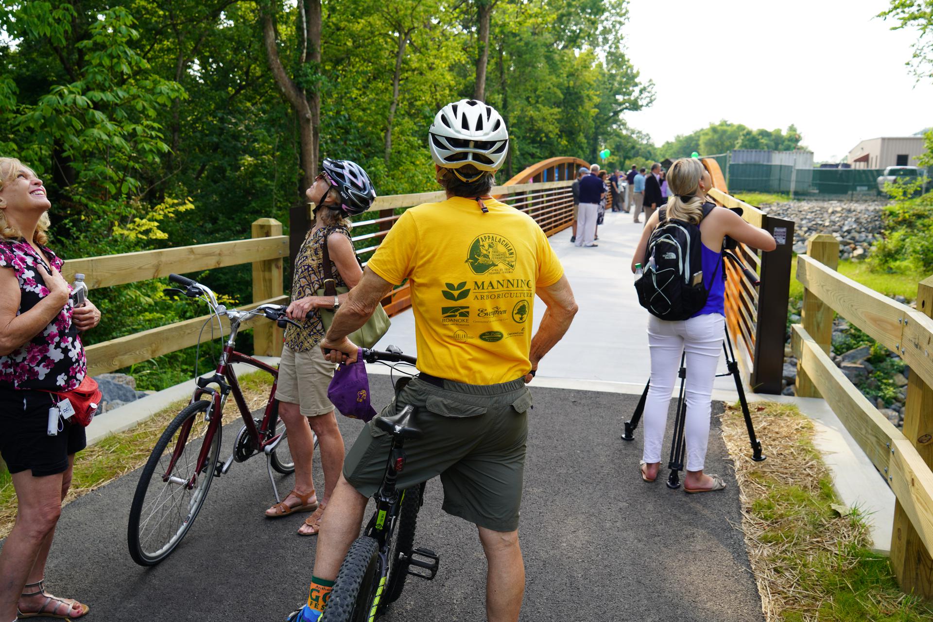
Bridge St Section of Roanoke River to open July 28th! Join us for the Ribbon Cutting!
July 13th, 2023The long awaited “Bridge the Gap” section of the Roanoke River Greenway in the City of Roanoke, connecting the current Bridge St Trailhead with the section along Aerial Way, will open officially at 10am on July 28th. The public is invited to join in the celebration, there will be coffee and snacks as well as Blue Cow Ice Cream as an incentive for those who stroll or roll the new trail! see the details on the flyer below.
The City of Roanoke is asking Greenway users to refrain from using this section until then, especially during work hours, as they are still finishing up last minute projects and will have equipment blocking the greenway.
20K for the Greenway, June 10th
May 18th, 2023Come out and support the Greenways by participating in this family-friendly event. Sponsored by Cardinal Bicycles, Pathfinders for Greenways, PedalSafe ROA and the City of Roanoke’s Parks and Recreation Department, this ride is designed to give casual riders a non-competitive event experience and to support the organizations that make the Greenways possible. More details can be found on the sign up page here.
There are some optional tune up rides on Wednesdays in May, but the event is June 10th.
Support the Greenways through Roanoke Gives
April 17th, 2023The Annual Roanoke Gives Fundraising Campaign is this Wednesday, April 19th. Pathfinders for greenways is participating, so if you would like to see the Greenways throughout the Roanoke Valley continue to grow and thrive, please consider giving this week. You can find more information here.
Update on the Opening of the Bridge St section of Roanoke River Greenway
March 10th, 2023Here is a great video that provides a bird’s eye view of the Roanoke River Greenway Bridge St section as well as some behind the scenes discussion of the progress. The expected opening is Late Spring/Early July.
Rains bring multiple closures of the Greenway on February 13th.
February 13th, 2023An Update from Roanoke City Parks and Recreation –
We got a lot of rain yesterday in the valley and surrounding mountains. This morning the Roanoke River is 5,000cfs, highest we have been since May 2022. With that, we are underwater in the following areas and will clean up debris once the water recedes. We do have almost an inch of rain forecast for Thursday, so water levels will rise again and I anticipate flooding for the end of the week in our lowest lying areas (low water bridge in Smith).
Roanoke River Greenway both low water bridges (between Wasena and 581), under Franklin Road, under Jefferson St, under 9th Street and along Bennington Rd SE.
Tinker Creek Greenway under Dale Ave, near Kenwood under both RR trestles. Under the RR trestle near Wise may or may not be under. Staff are checking this morning.
Please check PlayRoanoke.com or the city’s social media accounts for updates as the river recedes.
Roanoke River Greenway in Salem to be temporarily closed
January 9th, 2023Beginning today, January 9th, and lasting until late February, The Roanoke River Greenway near the Moyer Sports Complex will be closed as the City of Salem continues construction to the facility. We’ll update the site when the trail is re-opened. Thank you for your patience.
Pathfinders For Greenways 2022 Newsletter
December 3rd, 2022
|


Roanoke County to hold meetings on potential for West Roanoke River Greenway
October 7th, 2022Roanoke County is conducting a Feasibility Study for the Roanoke River Greenway between Green Hill Park and Montgomery County. This proposed extension of the Greenway has long been a goal of the Greenway Commission and has appeared on every vision map since the first Greenway Plan was adopted. This section has gotten some new energy with the planning efforts around the Valley to Valley Trail, which would connect the New River Trail and the Huckleberry Trail in Christiansburg to the Roanoke River Trail.
In October 2022, Roanoke County will host two community meetings in the Glenvar community on October 19th and 20th. The meeting will be to solicit community feedback and help identify the desired potential corridors. For more information, please go to the Roanoke County website for the details.
National Public Lands Day, September 17th
August 26th, 2022Join Roanoke County and fellow trail enthusiasts at Explore Park for a day of giving back to our public lands. The project will be to reroute a section of the Yellow Trail between Chestnut Ridge Road and the Blue Ridge Bike Park. We will be constructing about 700 feet of new bench cut trail and a climbing turn, replacing several eroded sections and a series of steep switch backs.
DETAILS: Sign in and day of registration will be between 8:30 and 9am at the RV lot across from the Explore Park Visitor’s Center before heading to the worksite. No trail building experience necessary, just a willingness to learn and an ability to work hard. Dress appropriate for the weather, but long pants are encouraged. Boots are recommended, closed toe-shoes are required. Bring work gloves and water, Virginia’s Blue Ridge will be providing lunch and t-shirts for pre-registrants. Work should be concluded by 1pm.
Registration can be found here. https://roanokecountyparks.com/548/Volunteer-Work-Day
Take the survey to Support the East Roanoke River Greenway
July 5th, 2022Help complete the East Roanoke River Greenway! Roanoke County and VDOT are working on the potential future alignment of the Greenway from Roanoke City to the Blue Ridge Parkway. Funding for this project is dependent on demonstrated community support, so the more people we can get to take the survey and say “yes, I want to see this happen”, the more likely it will be that the necessary funding will be made available. This will be a pretty unique section of the Greenway, winding through the river gorge towards Niagara Dam, before heading under the Blue Ridge Parkway and then on to Explore Park. Work on the section near Blue Ridge Parkway will start next year, and the goal is to continue on to Explore Park by 2025. That will leave the portion that is the focus of this survey as the missing link to connect the Roanoke River Greenway all the way from Salem to Explore Park. This project has long been talked about, now is the chance to help make it a reality. The survey closes July 15th, so don’t wait too long to share your thoughts!
Link to the plan details and survey can be found here.
Clean Valley Day Clean Up On Tinker and Glade Creek Greenways, April 9th
April 1st, 2022Come join us for a litter clean up on the Greenway April 9th from 9 until noon. We will be meeting at the Dale Ave SE Trailhead for Tinker Creek Greenway. Wear clothes you can get dirty and sturdy shoes, bring water, and we will provide the rest. Any questions please contact Frank Maguire.
High water forces temporary closure of Roanoke River Greenway and Tinker Creek
February 4th, 2022Due to the rain and the forecast for more in the coming days, the section of the Roanoke River Greenway that parallels Wiley Drive between Wasena and the second low water bridge will be closed from today, Tuesday May 24th until further notice. Tinker Creek Greenway is also flooded near Dale Ave and near Kenwood, so please avoid these areas.
Even when the water recedes, debris will remain on the trail surface, creating potentially hazardous conditions. Please find alternative routes to avoid this area. Roanoke City Parks and Recreation Staff will monitor the situation and send cleaning crews as soon as feasible.
Brief closure of a section of Roanoke River Greenway this Wednesday
January 24th, 2022As AEP continues to work on upgrading their equipment, there will need to be another temporary closure and detour of the Roanoke River Greenway. This Wednesday, 1/26, the closure will be in the vicinity of the Walnut Avenue Bridge. Greenway users will be routed on to neighborhood roads from 6am to 6pm to avoid the work area. The reroute will be signed and does require crossing Walnut St. Work should not extend into a second day.
UPDATE: The work was completed on schedule and the trail is reopened as of the end of the day.
Missing Link in Roanoke River Greenway to start construction this Spring
January 21st, 2022Roanoke City has awarded a contract to Allegheny Construction to construct the approximately one mile section of trail from the current Bridge St Trailhead to the section that currently ends at the Norfolk-Southern Materials Yard. This project has been the focus of the city, the Greenway Commission and the Pathfinders for Greenways for years, and will largely complete the Roanoke River Greenway within the Roanoke City limits. The project includes going under the Bridge St Bridge, under two NS bridges and a new, 270-ft bridge across the Roanoke River. Add into this some other design challenges and it explains the lengthy process to get this completed. Construction is slated to begin late Winter and should be completed by early Spring, 2023.
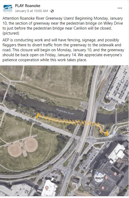
Temporary closure of Roanoke River Greenway Section – UPDATE
January 11th, 2022The work has been completed and the Greenway is now open. AEP will being doing utility work in the area where the Roanoke River Greenway goes under Jefferson St SW, near the Carilion Roanoke Memorial Hospital, necessitating a closure and detour. Greenway Users can follow Wiley Dr. under the Norfolk Southern bridge and return to the Greenway just past the pedestrian bridge. The work should be completed this week with the Greenway re-opening on Friday, January 14th.
November 17th, 2021
Pathfinders for Greenways 2021 Newsletter Dear Greenway Supporters, It has been a few years since we connected through this newsletter. During that time and despite the pandemic, much has transpired on the Roanoke Valley Greenways. Our Greenway Partners have made several new connections: Barnhardt Bridge connecting the Cities of Salem and Roanoke for the first time; Hinchee Trail providing a connection to Carvin’s Cove; and the Catawba Greenway connecting to the Appalachian Trail at McAfee Knob. We’ve also helped our partners to secure land to complete the greenway section along Walker Foundry, to obtain a critical easement for a future path to Explore Park, and to double the size of the Read Mountain Preserve. We revamped our website, www.greenways.org, to provide a more interactive and comprehensive trail directory and to improve usability on mobile devices. We also launched new software called Bloomerang to improve our engagement with our generous and loyal donor and volunteer base. Finally, we completed a critical leadership transition bidding farewell to our Greenway Coordinator for 25 years, the amazing Liz Belcher. She has done so much for the Greenway system that it would take volumes of newsletters to do it all justice! We welcome our new Coordinator, Frank Maguire, to lead us through the next chapters of Greenway expansion. In our community, we are so fortunate to have a wonderful Greenway system that enables us to safely connect, exercise, and refresh on our natural and paved trails, even during a global pandemic. The expansion of the Greenways would not be possible without each of you. Our tireless volunteers on the MidWeek Crew and the Rock and Roll Crew donate their time to blaze, repair, and maintain trails. Our generous financial donors enable us to support the localities with land and easement acquisitions and close budget gaps to purchase materials and engineering to complete projects. On behalf of the Pathfinders, I sincerely thank you for your past and future support of the Roanoke Valley Greenways! Gratefully, Brian R. McCahill President Pathfinders for Greenways 


Barnhardt Bridge ribbon cutting
Volunteer Accomplishments 2020-2021
Total Volunteer Hours: 6,666.8 Total work days: 254
Main Projects:
1/2020-8/2021 Rock-N-Roll Trail at Carvins Cove 2/2020-5/2021 Catawba Greenway 1/2020-2/2020 Comet Trail Improvements at Carvins Cove 5/2020-7/2021 Happy Valley Road Repairs at Carvins Cove 8/2020-9/2020 Buck Trail Relocation at Carvins Cove 5/2021-7/2021 New Laurel Canyon Trail at Carvins Cove 5/2021-8/2021 New Mill Mountain Trail #15
Our Contributions 2020-2021
Barnhardt Bridge – $48,689 for engineering Glade Creek Greenway – $45,000 for a shelter and right of way access Read Mountain Preserve – Funded transaction costs for land donation Eastern Roanoke Greenway – Purchased and donated easement Western Roanoke Greenway – Purchased and donated easement

Volunteer Of The Year 2021: Turtle Eddins 
Mill Mountain Trail 15 ribbon cutting by MidWeek Crew 

I am excited to be stepping into the role of Greenways Coordinator and the chance to work with the Pathfinders. When my wife Beth and I started thinking about places we wanted to live, high on our list was an engaged community with a great network of trails and greenways. Roanoke was the first place we visited and once we did, we pretty much stopped looking. So thank you for creating such a beautiful and vibrant place! I have spent the last 23 years living in Pennsylvania in the heart of the Appalachian ridges and valleys. In PA I returned to an earlier passion for the outdoors, getting involved in local public lands advocacy and becoming a trail volunteer. I served on PA’s recreation advisory committee and as the International Mountain Bicycle Association (IMBA)’s state representative, getting involved in a 32-mile trail project that took seven years to complete. In 2009, I was hired to be IMBA’s Mid-Atlantic Regional Director. I first came to Roanoke in this role, participating in planning meetings for the Blue Ridge Parkway and helping form Roanoke IMBA. In 2015, I became the Trails Program Director for the Pennsylvania Environmental Council (PEC), where my work focused primarily on rail-trails as well as managing the PA Water Trail Partnership. In this role, I saw myself as a voice for protecting the places people play. I strongly believe that when people have a connection to the landscape, they have a deeper understanding of the environment and why open spaces are critical to our wellbeing. I realize I have very big shoes to fill; Liz, the Greenway Commission and the Pathfinders are used as a reference far and wide for how to create a bold vision and work tirelessly to make it a reality. I look forward to working with Pathfinders, including the generous donors who make it possible, and everyone in the community to complete that connected Greenways vision. Best, Frank Maguire Roanoke Valley Greenways Coordinator

A proper send off to Liz for so many years of dedication to expanding our Greenways 
Greenway t-shirt quilt gifted to Liz by Roanoke County Parks & Rec. 


Hinchee Trail ribbon cutting Friends, You may have heard that I retired on the 25th anniversary of my start as the Greenway Coordinator. Formation of Pathfinders was a big step in the first year. I still get asked, once by a Romanian, how we got the URL “greenways.org”. A board member with foresight did it, long before I had heard of websites. Pathfinders has been an important part of the growth of the greenway network – volunteerism, fundraising, trail building, marketing, advocacy. I do not remember a single time when I asked the Board for support and they hesitated – always they said “go for it.” Money, time, sweat, Saturdays, meetings. Do it. Purchase of the Hinchee Trail to connect to Carvins Cove was certainly a crowning achievement for Pathfinders and for me, a legacy to the valley. I am not gone. I will continue to work with the MidWeek Crew and hope to spend more time enjoying the great network we have built. See you there. Aufwiedersehen, Liz Thank you for your 25 years of service! 

Catawba Greenway ribbon cutting www.facebook.com/roanokevalleygreenways Check out our new website for greenway maps, opport-unities to volunteer, and online donations. 


|
Repaving completed on eastern end of Roanoke River Greenway.
October 22nd, 2021The City of Roanoke’s Parks and Recreation Department has completed the repaving of the Roanoke River Greenway from the the Bridge at Bennington Road to the Shell Station. This project was necessitated by the growth of invasive trees along the greenways, which had buckled the pavement. The Pathfinders’ Midweek Crew helped city staff remove the invasives over the course of several weeks, and the paving was completed ahead of schedule.
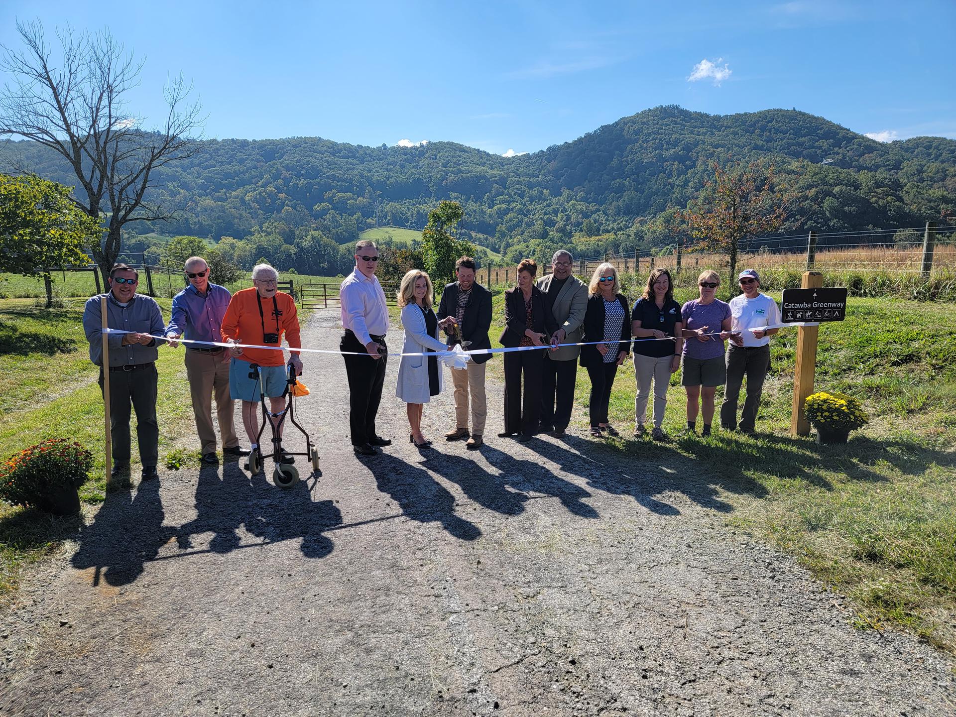
Catawba Greenway now open
October 4th, 2021Long in the making, the Catawba Greenway was formally unveiled on the last day of September. Connecting Virginia Tech’s Catawba Sustainability Center with the Appalachian Trail near McAfee Knob, the new trail creates a little over a 5 mile-loop for hikers who wish to access the AT without worrying about parking on the top of 311.
The trail itself utilizes parts of the original RT 311 roadbed, before transitioning onto purpose-built trail completed by the Pathfinders for Greenways Midweek Crew. The crew’s work includes impressive stone tread and several stair sections that will help hikers ascend the elevation changes. The trail also showcases VA Tech’s agricultural research facility, from American chestnut plantings to riparian buffer crop studies. The first six-tenths of a mile is intended to be a more accessible trail and includes a bridge across the Catawba Creek and a shelter complete with accessible picnic tables.
The Catawba Greenway Trailhead is located at 5061 Catawba Creek Road. Please consider using this access area for the AT if you arrive at the top of 311 and see that the parking area is full. The surfaced lot will hold 25 vehicles, but there is optional overflow parking as well. Additionally, another dozen or so parking spots are available at the Roanoke County Catawba Community Center, located at 4965 Catawba Creek Rd.
For a better sense of the trail, the scenery you’ll encounter and the partnerships it took to bring the trail to life, check out this video from the ribbon cutting. https://www.youtube.com/watch?v=g8l282vCaDs
If you plan your trip for a Thursday, be sure to visit the Catawba Farmers Market, open May through October. More details can be found at Catawbafarmersmarket.com
Roanoke River Greenway Repaving!
October 4th, 2021If you have traveled on the Roanoke River Greenway near the Bennington Rd Trailhead, you have undoubtedly noticed the pavement has risen up in several sections, making for a jarring, possibly dangerous surface. These pavement heaves are caused by the adjacent invasive trees, whose roots have grown under the pavement in search of water.
Beginning the week of October 4th, Roanoke City’s Parks and Recreation department will begin to tackle this issue head on. The offending trees are slated to be removed, replaced by new plantings that shouldn’t create this headache in the future. Once the tree removal is completed, a stretch of the greenway will be repaved, greatly improving the experience for all users.
The work will take several weeks, so in the meantime the trail will be closed (between Bennington Rd Trailhead and the Shell station) until the work is complete. Consider exploring another section of the greenway and look forward to a smooth trail soon!
For more information and updates, please check the Roanoke City Parks and Recreation Blog.
Roanoke Valley Greenway Coordinator Announces Retirement
May 13th, 2021Roanoke, VA, May 13, 2021 – Liz Belcher will retire in August as the Roanoke Valley Greenway Coordinator after 25 years. Liz began working as coordinator in 1996 when the Greenway Steering Committee was a fledgling organization at the Fifth Planning District Commission. The regional Roanoke Valley Greenway Commission was formally established in 1997 by the City of Roanoke, Roanoke County, City of Salem, and Town of Vinton. Botetourt County joined in 2016. Liz has been the only employee of the Commission, coordinating with the local governments to build a greenway network.
During Liz’s time with the Commission, the greenway network has grown to include over four hundred miles of off-road greenways and trails, with the 1996 Greenway Plan updated twice (2007 and 2018) to reflect the expanded vision for the region. The Roanoke River Greenway, running west to east through the valley, is the backbone of the network, with north-south routes connecting to the public lands encircling the valley. Mason Creek, Lick Run, Tinker Creek, Garden City, Glade Creek, Wolf Creek, and Mill Mountain Greenways provide the core of the north-south routes, connecting to the Blue Ridge Parkway, National Forests, Carvins Cove, Read Mountain, Appalachian Trail, and state preserves. Liz has been closely involved in protection of these public lands through conservation easements on over 13,000 acres with Virginia Outdoors Foundation and Blue Ridge Land Conservancy. She also helped organize the purchase and donation of lands for Read Mountain Preserve and Hinchee Park.
In 1999 the Greenway Commission and local governments hosted the first Governor’s Conference on Greenways and Trails. That Conference grew into a biannual event and then later into a state-led effort to expand greenway and trail networks statewide and capitalize on the economic impacts of outdoor recreation. In the Roanoke area, Roanoke Outside was born as part of the Roanoke Regional Partnership’s efforts to build an economy that valued our natural resource assets and to attract businesses, employees, and economic development to a bikeable/walkable community with great outdoor recreation opportunities. Greenways have been the foundational infrastructure for that vision and repeatedly appear in surveys and public input as one of the best things the region has ever done.
Liz has served on numerous boards and organizations, including the Roanoke Valley Urban Forestry Council, Transportation Technical Committee of the Transportation Planning Organization, State Trails Advisory Committee, Virginia Outdoors Plan Advisory Committee, Virginia Trails Alliance, Roanoke Appalachian Trail Club, Western Virginia Land Trust, and Blueway Committee. She has been a speaker for many civic organizations, an adjunct professor at Virginia Tech, and an instructor at Roanoke College and Hollins University. In addition to the greenway plans, she led development of the first local trail plans for Carvins Cove, the Blue Ridge Parkway, Green Hill Park, and Mill Mountain.
Frank Simms, Chair of the Roanoke Valley Greenway Commission, said that Liz “has been the face of greenways for the region and, although she is often given credit for their existence, this has been a community effort with the Greenway Commission, localities, staff, volunteers, and many, many supporters providing the impetus and expertise to make it happen. We all get great joy from seeing so many people from all walks of life using the greenways, loving the river and streams, and making greenways an integral part of their life and their family. Thanks to Liz Belcher and many partners, the Roanoke Valley Greenway system has become a reality.”
With the announcement of Liz’s retirement, the Greenway Commission will begin the search for a new Coordinator. Questions can be directed to Frank Simms at fmsimms51@gmail.com. For further information, see www.greenways.org .
New Striping on Roanoke River Greenway
December 30th, 2020There is a new yellow center line on the most heavily used sections of Roanoke River Greenway, from Memorial Avenue to Piedmont Park. Remember: travel on the right, pass on the left. Notify those in front of you when you need to pass.
Key property acquired for Roanoke River Greenway segment
December 22nd, 2020Roanoke City Council approved on December 21, 2020 the acquisition of right-of-way across Walker Foundry for the Roanoke River Greenway. This will allow the City to move forward on “bridging the gap”, connecting the greenway at Bridge Street to the greenway near the Materials Yard off Aerial Way. Construction is expected to begin in about six months.
The City is also moving forward with construction of a bridge across Barnhardt Creek to connect to Roanoke River Greenway behind Cook Drive in Salem. Construction of that link will begin in January 2021.
AEP Foundation Awards $30,000 for a New Roanoke Valley Greenways Website
August 17th, 2020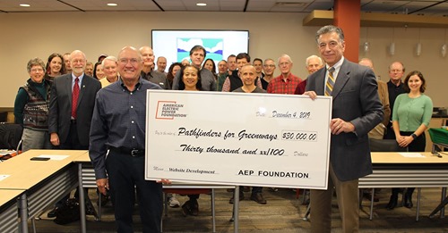
(December 4, 2019) A new Roanoke Valley Greenways (RVG) website is coming soon thanks to a grant from the American Electric Power Foundation. At the December 4th Joint Meeting of the Greenway Commission and Pathfinders for Greenways, Appalachian Power presented a check on behalf of the AEP Foundation for $30,000 to “power” the development of a sleek, modern website that will feature robust interactive maps.
This redesign of www.greenways.org is intended to attract new users to regional greenways and help longtime users discover new greenways and trailheads. The project, scheduled to go live in the spring of 2020, requires significant funding to update maps and replace an existing site that has become outdated. The new site will share important information about the greenway network like route characteristics and changes, nearby amenities and volunteer opportunities.
Appalachian Power is passionate about being involved in the communities where their employees work and live. The AEP Foundation, funded by AEP and its utility operating units, including Appalachian Power, provides a permanent, ongoing resource for charitable initiatives involving higher dollar values and multi-year commitments in the communities served by AEP. Information about AEP’s community impact is available at www.aep.com/community.
“Our greenways are a tremendous asset to our community,” said Larry Jackson, Appalachian Power external affairs director. “We’re grateful to have this opportunity to partner with the Roanoke Valley Greenways to make more people aware of our community’s network of greenways and trails.”
Appalachian Power in Virginia has a long history of environmental stewardship and of supporting nonprofits in the Roanoke region. This has been exemplified in the past by race and event sponsorships and by contributions to projects such as development of the Tinker Creek canoe and kayak launch on the Roanoke River in Vinton.